Contents
Index
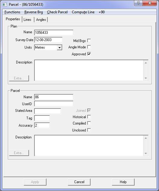
Edit Parcel
This option allows you to edit or alter the physical dimensions of the parcel. As you enter a parcel or alter a parcel,
a diagram of the parcel will be displayed in the left hand side of the program window.
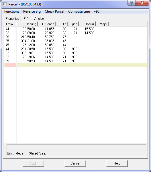
Data
The ‘From’ field contains a point number. Enter a point number or press ENTER to have the program use the next available point number.
When entering the distance, if you press ENTER it will automatically fill in the To point and the next From point.
If you enter the distance and press TAB, it will move to the To field and allow you to enter the point number.
The Bearing Field contains the bearing from the ‘From’ point to the ‘To’ point.
The Distance field contains the straight-line distance between the ‘From’ point and the ‘To’ point, and the ‘Type’
field contains the line type code. This is a special code that defines a particular line type.
To view the line type codes, see Parcel Tags
Reference marks are created by typing RM in the ‘To’ point, see Reference Marks
Insert Row
This option allows you to insert a new row into the parcel data between any two existing rows.
To ensure continuity in the parcel lines, the “to point” in the inserted line should be made the same as the “from point” in the next line.
Delete Row
This option allows you to delete a row from the parcel data. If the row is part of the parcel close,
you should then change the “from point” of the next line to make it the same as the “from” point of the line being deleted.
This will ensure the continuity of the parcel lines.
Check Parcel
Check the lot for accuracy, and display the misclose. The check will also include any looping traverses added to the main parcel close.
Reverse Bearing
This option will reverse the bearing of the line between the ‘From’ point and ‘To’ point by 180 degrees.
The bearing can also be reversed with the function six (F6) key.
Compute Line
If data for any line is not available but can be computed from the parcel close,
this option will compute a missing bearing or missing distance or both.
It is useful to help resolve dimensions which are difficult to read on a plan.
Parallel Line
This routine is used to complete the dimensions on road parcels where there are dimensions for only one side of the road.
It can also be used for any “strip parcel” such as an easement or drainage reserve.
The available data is entered and the option selected. A dialogue box will then appear and ask for the width of the strip
and the bearing of the boundaries at each end of the strip.
If the missing data is to the right of the known information enter a positive value for the width.
If the missing data is to the left of the known data, enter a negative value for the width.
The remaining lines for the parcel will then be generated.
Centreline Easement
This is used where an easement is defined by a dimensioned centreline and width.
The centreline is entered as an unclosed parcel and “Centreline Easement” selected
A dialogue box will then appear and ask for the width of the strip and the bearing of the boundaries at each end of the strip.
It will then generate the easement around the centreline.
Close Lot
Used to close the lines surrounding a parcel It sets the “to point” for the last line before any radiations or
easements to be the first “from point” and then calculates and displays the parcel misclose.
Road Centreline Lot
Where road centrelines are available as a framework for a parcel network, this routine can be used to generate
the connections from the centreline to the road boundary. Each road is entered as an “unclosed” lot and then this
option selected. A dialogue box will appear and ask for the width of the road. Connections will then be generated at
the tangent points for each curve and at each angle in the road.